GisOnline of the Hodonicetown was used to create passports for road signs, communications and lighting from the mobile mapping panoramas in 3D. It includes projects for the Mayor and the municipal council, asset administrator and the public. Nowadays, every citizen knows where the networks are passing around his real estate and he has information about individual parcels from the land register. The town owns a highly efficienttool for the asset management. Try it by QR code.

The progressive ones are tailor-made for a specifi c user and contain all the necessary data and tools to address the relevant agendas. They are easy to operate and intuitive, so that the user does not need to worry about how to operate the system, but
only use it to solve his tasks. The indisputable advantage of the modern web GIS portal is its ability to develop according to the needs of its users. TopGis company is continuously developing its GisOnline web mapping application, which easily mediates
mobile mapping for the municipality‘s city council, acts as a gis solution for a district town, or maps and records a small town assets. Scalability and complexity of a functionality are the key to a tailor-made information system.
: Big Data? Always at hand
For modern information systems it is no longer necessary to have all the data in local repositories and to burden the budget with the high cost of own data centres. Not only vertical and sloping aerial images, but also panoramic images of mobile mapping can represent a volume of data of the order of Terabytes for the city. TopGis web map services with the most detailed orthophotomap of the Czech Republic are optimized for the transmission of large data sets of maps and orthophotomaps over the Internet. The user only connects to the service and does not need to search for where various data are or to deal with their update. He can fully concentrate on his own work.
TopGis company continually develops the internet distribution of its large datasets from its own data store, usually Cloud, the reforeeven a small town can have its own mobile mapping data and sloppy imaging data available through web services thanks to the new technologies.
: TopGis, Ltd.
TopGis is a Czech company operating not only on the Czech market in the field of aerial imaging and mapping. In addition to a continually upgraded product of the Orthophotomap of the Czech Republic with 12.5 cm/pixel resolution it also provides
the orthophotomaps of towns with a resolution of up to 5 cm/pixel, oblique imagery and mobile panoramic imaging for mapping and for asset management. Data obtained
with the use of these technologies are provided from their own data storage via web services. A number of analytical tools change the visualization into an interactive information system and provide these interactive visualizations as high-end solutions. TopGis develops and operates the GisOnline web map application, a modern geographic information system, the implementation of which for Hodonicetown was
awarded in the Czech Smart Cities for the Future, 2017 contest.
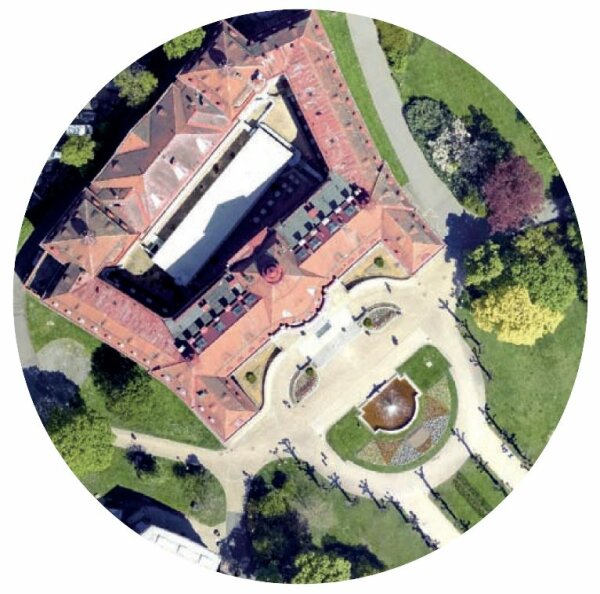
The orthophoto map with a 5cm/pixel resolution of the city of Karlovy Vary serves the city not only as a good quality map background but also for its technical map update. For the needs of architects, source vertical frames were used to create a 3D vector city model. A 3D visualization of the spa centre was created from the simultaneously taken sloping images for the promotion of tourism, which is publicly available to the general public from the city‘s website.
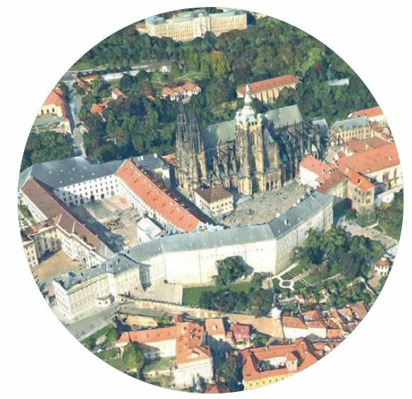
Adding GIS data to a web interactive 3D visualization creates a 3D information system with many analytical tools, such as direct visibility, measurement and 3D mapping.